
Survey And Geospatial
Conventional & GPS
Efficient field collection and communication technology.
Our survey department is staffed with an experienced team of Texas RPLS’s and fully equipped and experienced survey crews. We stay connected to the latest advancements in our field, applying the latest tools and technology to increase efficiency and confirm the quality of our deliverables.
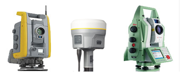 VICKREY’s robotic total stations eliminate potential human sighting errors and generate extremely fast and accurate horizontal and vertical measurements. Similar to robotic total stations, our digital levels eliminate potential human sighting errors and generate accurate electronic level readings. Our survey field crews are equipped with the latest survey controllers that run on a Windows Mobile platform with the ability to access hosted applications, geo-tag photos, stay remotely connected to the office and share data from office to project sites almost instantaneously.
Crews are also equipped with the latest GNSS GPS systems for use in high-precision static networks and real time kinematic (RTK) surveys. Our subscriptions to the Virtual Reference Station (VRS) network allows all crews to use wireless technology to obtain algorithms for positional corrections in real time throughout the state.
Our survey workstations are installed with industry-standard technical design, modeling, documentation, and calculation applications, including Civil3D, Trimble Business Center, Leica Infinity and other purpose-specific design tools. Our on-site production facility includes wide format copiers, scanners, laser printers and ink-jet plotters to provide full-color and black-and-white, presentation quality plans, exhibits, and bound reports. Drawings and project data can be shared with the client’s system, and/or may be delivered in hard copy format.